Last post we looked at hiking options in the lower part of Washington County, including the four towns south of the Battenkill: Easton, Cambridge, Jackson and White Creek. This time let's see if we can find some trails in the county's mid-section and then, sometime in the future, we'll finish up with a post focusing on the huff and puff hiking in the northern mountains.
Sitting on a Hudson Crossing trail. You are also allowed to walk here.
(web image)
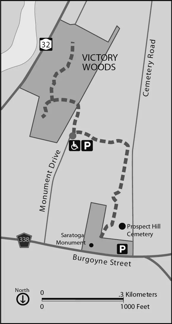
* Schuylerville feels like cheating (because it's on the wrong side of the river in Saratoga County) but there are some walks here that are too good to ignore. Hudson Crossing Park's two miles of trail are popular for their views of the canal and river. I've been running here for some 60 years (since way before it was a park) and it never gets old. Nearby is Starks Knob, a short, stiff climb to a sweet view. Connecting Hudson Crossing to the Village of Schuylerville, the Empire State Trail and Canalway Trail overlap and lead to a connection with the Victory Woods Trail System.
These three maps give you some idea of the Schuylerville area trails
* Denton Preserve is located north of Schuylerville. Drive across the Hudson on the Rt. 4 bridge and look for a small pull-off with a sign on the right. Walk across the old Champlain Canal thru a shale pit area to a trailhead with several diverging paths. The 330 acre property has unique shale hogbacks with vernal pools in between and sections of an abandoned trolley line. There is also a section between Rt. 4 and the river that's best seen by walking along River Road. If you've got a small boat there's a pond that can be paddled here in the spring.
* The Empire State Trail enters Washington County from Hudson Crossing Park via the Dix Bridge. From there it extends all the way to the northern border with Essex County (and beyond). Only parts of it are attractive for walking with some sections along busy Rts. 4 and 22 best avoided. River Road, both north and south of the hamlet of Fort Miller, is very pleasant with minimal traffic and lovely views. Another desirable segment begins in Fort Edward and extends to Fort Ann. You can also connect to the Feeder Canal Trail that leads up past the Five Combines locks, thru Hudson Falls and on to Glens Falls. Beyond Fort Ann there is town road walking with no shoulders to reach a nice but short stretch on abandoned Quarry Road. Best to use these maps to find parking and parts to explore.
The Empire State Trail from Fort Edward to Fort Ann
* Several sites that may become available in the future or have been popular in the past include:
- ASA's proposed Argyle Community Forest on Saunders Road which awaits trail development.
- Battle Hill just north of Fort Ann is slated to become a park commemorating the Revolutionary war engagement there.
- Egg Mountain, outside of Salem (in Vermont), with its archaeological resources may be open to the public at some point in the future.
- The Thunder Mountain Recreation Area in the Town of Greenwich off North Road has been popular in the past but I've heard that logging operations have made it less desirable.
- Bald Mountain, also in the Town of Greenwich, used to be fun to explore. I can remember skiing all over it back in the day. To the best of my knowledge there is no longer any public access. - Pumpkin Mountain, rising above Hartford is another lost area. It was formerly a very popular outing for locals but there is no longer any access.
Then...
...and now
(image from Green Mountain Dronography on facebook where you can watch a neat video)
* Carters Pond Wildlife Management Area is noteworthy for its wheelchair accessible trail and viewing platform. The 446 acre parcel features the pond and adjacent wetlands with trails at the southern end of the parcel. Several parking areas and a canoe launch add to the appeal. It's located in the Town of Greenwich on Co. Rt. 49.
* Several dirt roads in Greenwich and Salem are appealing destinations for a quiet walk. Try Riddle Road for great views and Binninger for tree shaded serenity. Hickory Hill and Roberson are also nice and a little exploring will turn up others.
The Owl Pen Book barns are located on Riddle Road
(web image)
* Salem Art Works offers a unique hiking experience as you walk amongst monumental sculptures on Cary Hill (where the Taconic views compete with the art).
(web image)
* The Pember Nature Preserve is located between Salem and Granville on Rt. 22. The 125 acre property has several miles of trails on either side of Black Creek. Access is from the quaint Porter Schoolhouse which is used as an environmental education center.
* Slate Valley Trails is a non-profit that manages 60 miles of multi-use trails in the Castleton, Poultney, Wells area of Vermont just over the border from Washington County. Visit their website for maps and trailhead locations. Also available for hiking and biking is the D&H rail trail running from Castleton to Rupert. Unfortunately, the section that extends to Salem has never been completed. Further into Vermont but definitely worth checking out are the trails at Merck Forest and the hike up Haystack in Pawlet.
A Slate Valley Trail leads to this viewpoint
* Fort Edward is a good place to wrap up this tour of hiking options in central Washington County. As previously mentioned, a section of the Empire State Trail extends north from the village. Also worth exploring is Rogers Island with its history stretching back to pre-colonial times. A little to the east of the village are several parcels of preserved grassland bird habitat with trails and observation areas.
After doing some (or all!) of these trails you deserve to sit a spell and catch your breath. Up in the next post is the tougher Adirondack Mountain terrain of northern Washington County. Sleeping Beauty here we come...


.jpeg)


.webp)


No comments:
Post a Comment