Wednesday, March 24, 2021

Outside Intervention

      Back then my idea of exotic travel was going to Lake George for an afternoon. It was twenty miles away, after all. A big trip.

     Outdoor adventure? That was when a cow had hidden her newborn calf in the woods and I had to find it.

     My recreational gear consisted of a balloon-tired bike languishing in a back of the barn junk pile. It was a rust bucket that hadn't been ridden in 25 years.

     And my environmental credentials consisted of picking up beer bottles from our roadside fields before a tractor tire found them.

     Then a friend gave me a dog-earred copy of a magazine that had seen the rounds. Told me to check out the last page, something called 'Parting Shot'. It was a photo of a free standing tent air-born over the summit of Buck Mountain. Lake George lay stretched out below. Pretty funny although it had 'staged shot' written all over it. The magazine was called Outside and I read it cover to cover. Liked it so much I've been reading it ever since.  


Original photo credit: Ed Burke


     It was like fog lifting from a socked in landscape. The stories and photos opened my eyes to a world I hadn't seen before. There were people exploring every last hidden corner of the Earth. There were runners, cyclists and climbers going faster, further and higher. Environmental activists dealing with big problems, dealing with more than roadside trash. Places, experiences and issues chronicled in word and image.


     Slowly, subtly my life began to change. I started running again, the first miles since school track and cross country. Then I bought a bike, a light 12 speed that I put thousands of miles on and still ride to this day. Got a canoe and wrecked it over on White Creek. So I got another and then another. Did the 90 miler one year with an 80 pound Grumman! Climbed mountains, bought a bunch of Peterson field guides, joined citizen activists fighting polluters. Even traveled a bit. Nothing too far flung but I have hiked into the Grand Canyon, camped in Texas and gazed in awe at Yosemite's El Cap.


     I always liked to read books but now I was more apt to be turning the pages of Norman Maclean, Thomas McGuane or John McPhee than of a Fleming 'Bond' novel. Started keeping a journal, started taking photos. Words and images again. In those days it was hard (nigh impossible) to put the two together. Words were on paper, images on film. Combining the two? Not possible in any kind of practical way. But those issues of Outside that came every month convinced me that marrying prose and pictures was the best way to capture experience, to share ideas. I didn't know it at the time but the impetus to blog had been seeded before the technology to do it had arrived. 
     These musings were prompted by the news that the magazine has recently been sold. Perhaps this is a good time to review a little history. Let's start in the 1970's, with two young men. Jann Wenner had launched Rolling Stone in 1967. It covered music, culture and politics. A few years later Wenner wanted to create an outdoor offering and assigned three of his staffers to come up with something. Tim Cahill, Michael Rogers and Harriet Fier got to work and 1977 saw Outside's first issue. There was almost a last issue a year later. The magazine stumbled and with the number of pages and number of issues cut it looked to be a very short run.


     While Outside was enduring a difficult birth, another publication covering some of the same turf had developed a small readership. Mariah was the creation of Larry Burke, a disillusioned young IBM exec who dropped out of the corporate world to travel the real world for several years. Coming back to Chicago and his family's business he started his shoe-string magazine in 1976. It's mission was to celebrate wilderness and the thrill of adventure.


      Legend has it that in 1978 Wenner knew he had to do something about his faltering magazine so he approached Burke about buying Mariah with the intent of using it to rejuvenate Outside. Instead, Burke, perhaps the better businessman, ended up buying Outside from Wenner and combining the two. There was a confused year when they were published under a combined title with an uneasy marriage of concept and content, but eventually Burke and managing editor John Rasmus got their act together. Mariah was dropped from the title and it's been Outside ever since.

A young and adventurous Larry Burke


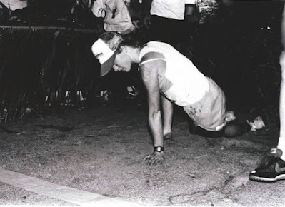
     The '70's were a culturally fertile decade. That's when Saturday Night Live and National Public Radio both got their start. There was lots of new music and something of a Hollywood golden age with such classics as The Godfather, Star Wars, Apocalypse Now and Taxi Driver. Athletes were exploring new territory as well. The first Hawaii Ironman Triathlon was in 1978. I remember Outside's coverage of the brutal battles between Dave Scott and Mark Allen on the searing Kona lava fields. Two of the fittest people who ever lived, they would go head to head for eight, nine hours pushing their bodies beyond what seemed humanly possible. And their duels seemed like fun and games compared to Julie Moss's 1982 performance. She started the race looking like a fashion model but some 11 hours later could have been mistaken for a concentration camp survivor. Befouled and nearly broken, she was unable to stand but kept stumbling and crawling thru the darkness towards the finish line and victory only to be passed in the last few yards. It was a portrait of grit and determination that once seen couldn't be forgotten.

Julie Moss - almost finished
Web image

        Triathlon and Outside came of age together and by the mid '80's the magazine was profitable and winning awards for excellence. Ed Abbey, Barry Lopez and Peter Matthiessen wrote for it. David Quammen (Natural Acts) and Mark Jenkins (The Hard Way) were popular columnists. Donald Katz's 'The King of the Ferret Leggers' became something of a cult classic and E. Jean Carroll's tale of an  all-female rafting trip down the Grand Canyon ('Women Who Run with No Clothes On') was a rollicking take on Clarissa Pinkola Estes' Women Who Run with the Wolves. Jon Krakauer's wrenching account of the 1996 tragedy on Mt. Everest (eight climbers died in a storm) first appeared in the magazine before becoming the bestselling book Into Thin Air
. Maybe not quite up to New Yorker standards but every issue had something literate, insightful and entertaining (although I never quite understood their obsession with expensive watches). 


Happy Anniversary - self congratulatory issues come along every few years

 
TAKE IT OUTSIDE...

    Decades went by, anniversary issues came and went and technology changed. A new generation of readers weren't necessarily readers at all, but simply consumers of what was on their screens. Outside adapted with an early and vigorous digital presence: website, Instagram, youtube channel and podcasts. They expanded into travel services and even a TV channel. And perhaps in the process the magazine suffered. It grew thinner and less frequent and in an echo of its beginnings, that portended a sale.

Outside Online screen shot

     The challenges faced by print media are well known. At Outside there had been hints of trouble for sometime. In online forums current and former employees complained of low pay and few benefits. They said the magazine didn't treat its freelance writers and photographers well, consequently losing the best talent. There were grumblings about 'the top of the masthead'. And diversity was all but absent. It was all about young, affluent white men. Recently there were 'special' issues meant to change this image but to some they seemed token, too little too late.


     It was like the number-crunching business devil whispering in Larry Burke's ear wouldn't let the editorial angel get a word in. He is in his late seventies and reportedly wants to work on his memoir, wants to spend time at his New Mexico ranch. It seems like he had become more interested in milking his cash cow than feeding her. Maybe it was time for a change. Maybe the sale is a good thing.
     Pocket Outdoor Media bought the magazine in February and quickly changed their company name to Outside. They own a slew of other active/outdoor publications including Climbing, Rock and Ice, SKI, and Velo News. They seem excited by and committed to Outside and have pledged to keep all the current employees.
     Magazines still have a role in recording events and accomplishments, in sharing experiences and ideas. They are where we can be challenged by those who have seen, done and thought about things beyond what most of us can imagine. Here's hoping a new generation can draw inspiration from Outside, much as I have for so many years. 
 

Outside's all-time most popular cover - I guess its readers like their rock


Thursday, March 11, 2021

Happy Trails?


     There's light at the end of the tunnel. I know. I was there the other day. I saw it.
     The tunnel goes under Rt. 196 east of Hudson Falls. It may well be the only tunnel in all of Washington County. It was built last year to accommodate the Empire State Trail. The trail here trends north/south while 196 is an east/west highway. Their intersection created a problem and a tunnel was the solution. A very expensive solution.
     Perhaps you have heard of the Empire State Trail. It was proposed by Governor Andrew Cuomo in January, 2017 and its completion was announced with great fanfare in December, 2020. It's a 750 mile multi-use trail, touted as the longest in the U.S. One segment goes from New York City to Albany where it branches, with a westerly route connecting to Buffalo and a third part continuing north thru the Champlain Valley to Canada.


     Much of the trail is on abandoned rail lines and canal towpaths. Unfortunately, most of the trail from Albany north actually follows roads. Most but not all. Recently, Gwenne and I skied an off-road part of the trail and checked out other local sections. In this post I'll share a little of what we found.


The Dix Bridge and shadow of a very tall photographer


     The trail enters Washington County via the Dix Bridge. For walkers and runners the trails on the Saratoga County side are hard to beat. From Hudson Crossing Park to the towpath back thru Schuylerville and on up to Victory Woods you'll be immersed in history. Naturalist will enjoy the large and diverse trees along the way and also the birds and wildlife drawn by the river and old canal. There's a visitors center, craft brewery and several restaurants in town. Definitely one of the nicest spots on the Empire Trail.


Along River Road (in a warmer season)


     Once across the Dix Bridge the first few miles are better suited to road biking than walking. The real fun starts when you reach River Road. Mostly dirt with a few paved sections, the trail here is great for walking, running and biking. It's also a popular spot for birding as the Hudson attracts a variety of waterfowl, especially in early spring. When we were there last week parts of the river were still iced over but open areas already had ducks and geese. After crossing Slocum Creek on a new pedestrian bridge you pass by the canal locks and the historic hamlet of Fort Miller before coming out to Rt. 4. I can't imagine anyone wanting to walk along busy Rt. 4 and the biking is just OK so it might be best to just skip this section and jump back on the trail in Fort Edward.


The Slocum Creek bridge


     From the Fort Edward Village Recreation Park north, the Empire Trail follows the old towpath which has been maintained by the Feeder Canal Alliance for many years. At a T intersection you can (and should) take a detour left to check out the Five Combine locks. This is also touted as the way for long distance bikers to visit Lake George by linking the Feeder Canal Trail with the Warren County Bikeway. Continuing straight at the T intersection used to bring you to a dead-end with the feeder canal, Bond Creek, the railroad and private property leaving no option but to turn back the way you came.


Two bridges and Bond Creek


     Not anymore. Enter New York State with gobs of money and now there are two new bridges that cross the feeder canal and Bond Creek as well as the aforementioned tunnel under Rt. 196. This allows an unrestricted connection to Towpath Road which continues north. Towpath Road is open to motor vehicles but it's dirt and lightly traveled. It's not bad for walking and biking plus you get to see some Washington County miscreants method of waste disposal - just dump your junk into the old canal.


Green is the Empire Trail & blue is the Feeder Canal trail and Warren County Bikeway


     In a curious route decision the Empire Trail bears right off Towpath and onto New Swamp Road. After crossing the RR tracks but before going over the Barge Canal bridge there is a parking lot serving an off-road section of the trail that parallels the canal up to Lock 9.


New Swamp Road parking lot and bridge

     I say 'curious' for several reasons. On a busy day New Swamp Road sees two, maybe three cars. Who is going to use a big parking lot out in the middle of nowhere? Both Towpath Road and the newly constructed trail lead to the same destination...Smith's Basin. Towpath Road functions reasonably well as a trail and with the clean-up of a few derelict properties it could be more scenic and interesting than the newly built path.


Towpath Road and the old canal at Dunham's Basin


     There are still crews working here on the trail. In talking to them I sensed pride in what they've created and gratitude for the employment. But there was also a barely concealed feeling of disgust at the way the state spends money. They've been working on this section of trail for two years and estimate the cost for just the Fort Edward to Fort Ann segment to be in the $12 to $14 million dollar range. As one guy put it, "My idea of a trail is to go out in the woods with an axe. Maybe open things up a bit."
     That is not the state's idea. In places they excavated two feet of dirt to backfill with stone dust. There was lots of heavy equipment involved, lots of steel bridges placed and railings installed. And that tunnel? Rt. 196 goes up and over the RR and the canal just a few feet away. Couldn't the trail have gone beneath that overpass? And with slightly different routing they could have gotten by with just one bridge instead of two. It seems that money was no consideration. Plow the way thru no matter what the cost. 

~~~


THE BASIN BROTHERS - SMITH AND DUNHAM...

     I feel myself getting hot under the collar so maybe it's time to cool down and enjoy some geography. The Empire Trail from New York City north to Canada follows a lowland that's part of a geologic feature called the Great Valley. A relic of plate collisions eons ago, it undulates along the eastern edge of the North American continent. In our area the Valley is underlain mostly by sedimentary shale with some limestones and sandstones. The Hudson River flows thru the Valley to the south and Lake Champlain (part of the St. Lawrence River system) occupies the northern Valley. The divide between the two watersheds lies between Fort Edward and Fort Ann.
     As you drive east from Hudson Falls on Rt. 196 you go down a hill and then quickly go up and over the RR/canal overpass before encountering what, for Washington County, is a long stretch of relatively level ground. This is known locally as the Adamsville Flats. The topography is of glacial origin. Hudson Falls sits on a large sandy delta built into Lake Albany some 13,000 years ago. As you  descend the hill on 196 you are driving off the delta and down its sloping face to the level clay sediments that settled on the lake bottom.


On this map brown (Is) is delta sand and light tan (Ic) is lake clay


     Lake Albany eventually drained but the area north of Rt. 196 remained a water-logged wetland that in colonial times came to be known as the Great Kingsbury Swamp. Swedish naturalist Peter Kalm wrote of being bedeviled by gnats, snakes and Indians during a 1749 trip thru here. The trees were mostly pine and many had fallen from age and storm making travel extremely arduous. Even after the Revolution, farmers and their livestock lived in fear of a pack of wolves that denned in the swamp where muck type soils consisting of saturated, decomposed organic matter kept most people out. The Empire Trail contractors got schooled in these soils when they buried a big trac-hoe so deep only the top of its cab was visible! In something of an understatement, soil scientists call these organic soils "highly compressible". 


Dunham's Basin is at the bottom where Bond Creek, the canal and 196 intersect
Smith's Basin is top right at the 149 label
The Great Kingsbury Swamp is above 196 and right of the canal


     Wood Creek drains the swamp to the north. It has always been a vital water route between the Hudson River and Lake Champlain. Native Americans had paths on the uplands above the swamp and these were used by the French and English in their long conflicts over the frontier. Burgoyne also came thru on his way to a drubbing at Saratoga. It's interesting to note that in times past the channel as far north as Crown Point was considered to be Wood Creek. Now it's known as the Narrows of Lake Champlain and with the building of canals the only intact part of Wood Creek is between the swamp and Smith's Basin.
     Activity reached its peak here after the Champlain Canal was completed in 1823. Both Dunham's Basin and Smith's Basin were commercial shipping hubs. When the railroad came thru there were stations at both locations. Parts of the swamp were drained with potatoes being grown and sent to market via canal boats. Eventually economic conditions shifted and traffic on the canal dropped off. Today the RR stations are gone and only a few houses remain at either location.


~~~

THE WAY NORTH...

     The Empire Trail passes thru the Lock 9 grounds, a lovely spot to picnic, fish and boat watch. After crossing Rt. 149 it continues between the RR tracks and the barge canal. There's another parking area on Baldwin Corners Road and short walk along the road  before continuing on to Fort Ann as a stone dust path. First views of the Adirondacks are seen here with Battle Hill looming ahead.


The trail south from Baldwin Corners Road


'Locking' into Fort Ann


     The approach to the village features a stroll thru one of the old canal locks. You can see fossils in the massive limestone blocks. There's a small park/docking area on the canal with a gazebo that's a good place to take a break. An attractive building with a timber framed entrance sits next to the trail. It was closed when we were there but looks like it might be some kind of food service. Hopefully it will open soon. Fort Ann also offers a craft brewery, restaurant and convenience store. It's a welcome stop after miles of trail.


         At Fort Ann you cross to the east side of the canal and continue on town roads. The plan is to make a connection between South Quarry Road and North Quarry Road for a short section of true woods walking. As you head towards Comstock there are two interesting cemeteries and nice views of the mountains to the west. The way past Great Meadows Prison is creepy but it's also a reality that more people should see and think about. Beyond there you just follow the shoulder of highways all the way to Canada. As a quiet trail it just kind of fizzles out.

Along North Quarry Road


     On the day of our visit we skied south from Fort Ann towards Baldwin Corners. The trail had been mostly used by snowmobiles, for which it seems well suited ( despite 'No Motor Vehicle' signs).There were the tracks of a few walkers ... probably local people out with their dogs. The skiing was actually pretty good as long as you stayed off to the side of the icy snowmobile track but it's also just a wide flat corridor and thus kind of boring. This got me wondering,  who will use the Empire Trail?


Gwenne skiing the Empire Trail


     Unlike such popular local paths as Spring Valley in Saratoga and the Betar Walkway in South Glens Falls, the Empire isn't that accessible for a quick stroll after work. It's wide open which means sunny and hot in summer and windy and cold in winter. Hikers want woods and mountains which they can find elsewhere. Perhaps long distance cyclists are the intended users but I know people who have done the Buffalo to Albany route and they said it was rather monotonous.


     An old skinflint like me finds the cost staggering and the payback questionable. I continue to believe equestrian trails are a perfect fit for Washington County. I also like the community driven nature of the CAT trails in Essex County just to the north. And the Cambridge Community forest currently taking shape adjacent to the village is inspiring. For perhaps no dollars and just a little effort, a nice canoeing route could be opened up on what's left of Wood Creek from Rt. 196 to Lock 9. The creek has been used by people for as long as people have been here - at least 10,000 years. Now it's all but inaccessible. That's sad.


Wood Creek


     I could go on and on. Waterfalls, scenic vistas, historic sites. Places that used to have a path and be popular spots are now off limits. Perhaps what is needed, more than big budget projects, is a slight change in attitudes. Freedom is one of America's most cherished values. Shouldn't that include the freedom to enjoy this land's natural wonders, both big and small? Ever since we first stood upright, humans have been on the move. Always exploring. It's our essential nature. Anything that allows us to move more freely thru our world is a step in the right direction.


Oaks along the Towpath