A riddle: Where did boats once float over the top of other boats?
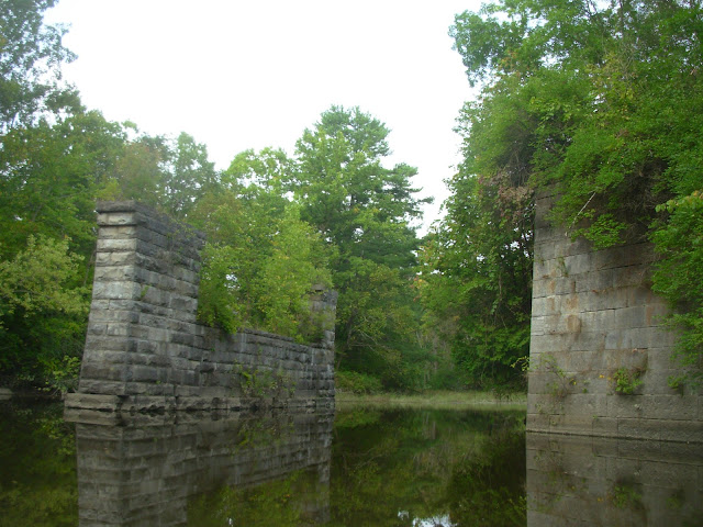
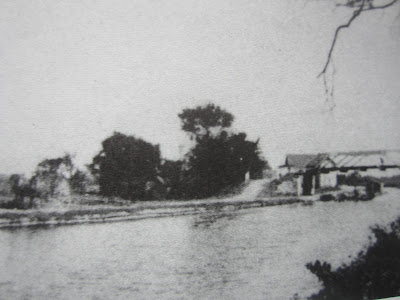
And the answer is: On the Moses Kill in Washington County where an aqueduct carried the Champlain Canal and its barge traffic high above the creek and any canoes or rowboats that were on the stream below.
Then...
...and Now
Today you can be in one of those canoes below, but you'll have to use your imagination to have a canal boat float overhead. It's just one of the many small pleasures to be enjoyed on one of my favorite paddle trips.
Time for another riddle: What stream that's totally in Washington County is best approached from Saratoga County? The answer is once again the Moses Kill and the explanation is that there's no good launching point where the 'Kill joins the Hudson in the Town of Fort Edward. More on this later but for now I'll describe a recent trip where I started from West River Road in the Town of Northumberland, Saratoga County.
Heading north on Co. 29 (West River Road) just past Wells Lane you can see the Moses Kill entering the Hudson River on the east side. There is NYS Canal Corp land here and I usually park on the left (west) side of the road where a sloping shoulder is possible but not ideal. Carry your boat across the road and look for an open spot down the short, steep bank where you can get to the water. Once you're afloat it's a quick crossing of the Hudson to the mouth of the Moses Kill. Don't go downriver because there's a dangerous dam/falls. Stay well above a line of buoys and you'll be fine. Do take note of the Barge Canal entrance on your right. It's a source of motorized boat traffic but also another possible approach to the Moses Kill.
The Moses Kill meets the Hudson just below the Rt. 4 bridge
You enter the 'Kill by paddling under the Rt. 4 bridge. It's just a level stretch of the busy road supported by huge beams. Most drivers probably don't even know they're crossing water. Too busy Texting. Just beyond you'll see stone block abutments. This is a former Rt. 4 crossing site but the bridge is long gone. In the past people have accessed the creek here on the north (left) side but it has become overgrown and dangerous to pull-off the highway thru an opening in the guardrails. On the south side Richardson Lane comes off Patterson Road right up to the stream bank. While there is one private residence here, New York State owns much of the surrounding land. This would make an ideal launch site. With a quiet public road and public land already existing, all that's needed is a designated parking spot and a short path to the water. Zero cost and safe, convenient access to a wonderful natural and historical resource. I hope it happens but I'm not holding my breath.
Old abutments and Richardson Lane off Patterson Road.
Beyond the new/old Rt. 4 crossings the stream takes on a wilder character. Low lying shores are lush with aquatic vegetation and silver maple groves lie a little inland. This is the realm of herons overhead and turtles tumbling off every log. Birders and plant lovers will be tempted to linger but those who push a little further upstream are in for a treat. Two artifacts of transportation from another era cross the creek one after the other.
First you encounter the cut limestone piers that held up the Champlain Canals Aqueduct #4. The canal boats traveled over the 'Kill in a wooden trough with a towpath alongside. This no longer exists but is easily visualized. The water to fill the canal came from up by Fort Edward which is that much higher than where you float in your canoe. There was a lock off to the right that acted like a stair step to raise the boats from the Fort Miller level to the Fort Edward level.
Will Patterson operated a store here and there was a school where Susan B. Anthony taught. A boat basin where repairs were made adjoined the canal. There was even a haunted house that the boaters feared passing at night! In the late 1800's this was a busy place, much more open and developed than what you see today. Curiously, at one time the settlement was called 'Mock'. Along with an accessible canoe put-in, an interpretive panel detailing the history and layout of the former Moses Kill community would add to the enjoyment of a visit.
From the aqueduct it's a short paddle to the next "Wow" moment as a graceful cement arch bridge comes into view. This structure carried the Hudson Valley electric trolley line over the water. It was built around 1900 and transported passengers from Troy to Lake George (and possibly on to Warrensburg?) for nearly thirty years. I believe it ceased operation after damage from the 1927 flood. In 1904 a round trip from Johnsonville to Lake George by train and trolley included a cruise to 14 Mile Island aboard the Horicon steamboat, all for $1.00! There was a substation of the line here at Moses Kill, while perhaps the best place to see the preserved bed of the trolley line is at the Denton Preserve off Rt. 4 between Northumberland and Fort Miller. Also visible at Denton are remnants of the old canal.
The three photos above are from an early spring trip to Denton Preserve.
You can see the trolley bed, a pole holder and a piece of glass insulator.
After paddling beneath the arch bridge (good for echoes) the shoreline begins to change. Shale ledges frame the channel with pines and hemlocks towering above. Here the 'Kill has cut a small, narrow gorge thru the bedrock. In a couple of places the water is so shallow you may have to get out and lift your boat (wear old sneakers) but it's worth it to continue up to a T where Dead Creek comes in on the left and the Moses Kill turns right. You can go further on both streams but much depends on water levels, log jams and your own sense of adventure.
My return trip back towards the Hudson felt like time travel. I imagined 450 million years ago when the Taconics were rising up high and mighty just to the east. Their barren slopes shed sediments into a deep, broad trough filled with sea water, the result of colliding plates buckling the crust of the earth downward. Over many millions of years the mountains eroded and the trough filled with mud that became the shale that I was drifting over and through. Originally horizontal, these rock layers now lay at crazy steep angles, shoved and twisted by the tectonic forces of a restless planet.
Shale outcrops with tilted bedding are found thru out the Hudson Valley
Eons later glaciers buried and scrapped the land. When the climate warmed and the ice waned great muddy lakes formed. After these post-glacial lakes drained, the clays that had settled to their bottoms formed rich soils lush with vegetation but also imparted a cloudy character to the streams that flowed across them.
In this google earth screen shot notice the difference in color of
the clay laden Moses Kill where it enters the clearer, darker Hudson River.
West River Road in Saratoga County (my put-in) is on the left.
Richardson Lane approaches the stream from Patterson Road at the bottom.
Look closely for the aqueduct abutments and trolley bridge upper right.
Over time the waterways and woodlands filled with fish, fowl and wildlife and these in turn attracted the first paleo-indians. Tom Ellis, who farms near Dead Creek and the Moses Kill, has an interesting collection of stone points that have turned up as he worked his fields, testament to the natives who once fished and hunted here. When you're in a canoe silently gliding below high, forested banks it's hard not to look over your shoulder a little nervously, wondering about and maybe watching for those who once roamed these parts.
At one point in the shale gorge a trickle of water seeps down the rock wall. It has left a light deposit that has the unmistakeable odor of a mineral spring. With the sites of the Vita and Lick Springs just to the east and the famous waters of Saratoga not far to the west, I wonder if this fount has the same source? It wasn't long ago when springs like this were popular gathering spots drawing people by the hundreds.
The trolley arch, canal aqueduct, old bridge abutments and modern highway span are passed in quick succession. Each speaks of evolving transportation technology and the lifestyles it fostered. Finally my little canoe inched out into the broad Hudson just as a speed boat came zipping down river. I experienced a brief moment of panic before they saw me and graciously slowed to a crawl. Nothing like the threat of being torpedoed to snap me back into the present after my tour of times gone by.
* All the historical black and white images in this post come from a delightful little book called The Champlain Canal: Mules to Tugboats by Captain Fred G. Godfrey. It's in local libraries and you can purchase a copy from the Washington County Historical Society in Fort Edward.


