This may be a case of saving the biggest (and best?) for last. Over time I've posted about exploring the state forests of southern Washington County. All except for one. That would be Mount Tom State Forest. At 1724 acres it's more than double the size of any of the others. A lot to explore so let's get started.
This large, irregular shaped block of land lies southeast of the Village of Cambridge near the Vermont border. You can drive a clockwise circle around it by going out Ashgrove Road (Co. 67), turning right onto Chestnut Hill Road, then taking another right onto either Lincoln Hill Road or, going a little further into the hamlet of White Creek to access Co. 68. Finally, one more right turn will put you on Rt. 22 back to Cambridge. It's a scenic drive of farms and forests, streams and mountains easily done in a leisurely half hour.
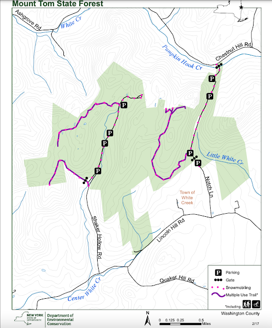
The easiest way to immerse yourself in Mt. Tom might be a traverse of the Notch Truck Trail. As the name implies, this is a rough road best suited to 4x4 trucks and then only in summer and fall. It bisects the eastern side of the forest from Chestnut Hill Road to Lincoln Hill Road. No 4x4? No problem. This is a fine route on foot, mountain bike or horseback. One other option is to ski it. That is what I did on the first day of spring. It's a nice little trip but not without its challenges.
I risked the travel and am glad I did
My first mistake was to start from the Chestnut Hill Road end. When there's snow (sort of needed for skiing) there's no place to park. It wouldn't be Washington County if they made an effort to accommodate the visitors that are encouraged to come. A few swipes with a plow is all it would take. After pulling off the road and into the snowbank as best I could, the next hurdle was mashed potatoes. At least that's what I think they call the wet, heavy spring snow I encountered. It's tough to make turns in but doable for straight ahead X-C touring.
A sign, a gate and a gentle slope quickly leads to a crossing of Pumpkin Hook Creek which was flowing busily on this warm, melting day. Then comes the longest uphill of the trip. It warms you up nicely and there's the promise of a fun run down on the way back. Most of the Notch Trail is actually level to gentle grades, somewhat surprising given the rugged terrain surrounding it.
Broken and bent trees from a recent heavy snowstorm were the biggest obstacle I encountered. Chainsaw work will be needed before the route is drivable. Other than that it was an easy ski until the far end where direct sun had melted most of the snow exposing dirt and rocks.
The Lincoln Hill end of the Notch Trail
You're at the wrong place if you want precise time and milage info. I gave up on watches and such a long time ago. My best guess would be that it's a couple of miles one way and can be done in a relaxed hour out and another hour back. From Lincoln Hill Road the Notch Trail is plowed for a ways and there is parking where the trucks turn around. This might be a better place for a ski start.
A few observations: the trail traverses an attractive mixed hardwood forest with lots of hemlock sprinkled throughout. There are small rivulets and pools of water beside the path for much of the way. Rugged ledges and dislodged boulders hem the road in places and there are a couple of unobtrusive camps mid-way, apparently private in-holdings. There may be snowmobiles at times and though ATV's are prohibited...well, you know how that goes. The only other tracks I saw were those of a snowshoer coming in from the south end. Light use seems to be the norm but it's probably best to avoid during hunting season.
The Notch is just one small part of the state forest. Other points of interest include an abandoned lime kiln and quarry, various summits and wetlands, a tree seed orchard and the site of a former settlement. And the Mount Tom that gives the forest its name? I'm not sure where that is. Guess I'll have to come back and try to find it.


Hi Don
ReplyDeleteI was excited to read this week’s blog post about mount Tom state forest! I have been exploring it this winter on xc touring skis too. There’s a lot of amazing terrain and wilderness. I found giant maple and oak trees, bogs and ponds, beginnings of creeks, rocky hillsides, lots of hollows and spring ephemeral streams, mushrooms and lichen and old stone walls. I also don’t know where mount Tom is though I’ve been to most of the peaks now!
Stephen Holbrook
Your comment got me stoked to return to Mt. Tom forest. You obviously know it much better than I. My skis have been put away for the year but April is a good month for walking in the woods, before the leaves and bugs come out. The Adirondack and Green Mountains get most of the love but for some of us the Taconic hills are our heaven. There's actually quite a bit of public land to explore along the border from Bennington up towards Poultney. Maybe I'll put together a list and post it when I get a chance. Thanks for your comment and the inspiration to get back to Mt. Tom forest again.
Delete