Monday, February 29, 2016

A River Runs To It

     Old friends full of new surprises always make me smile. Take the Battenkill State Forest. To me it's like an old friend that shares new secrets every time we get together. Running through this relationship is the Battenkill itself and the whole "No man ever steps in the same river twice" thing. The flow of water and time keep a stream both familiar and fresh. Like a friend that's always constant, but also always changing.


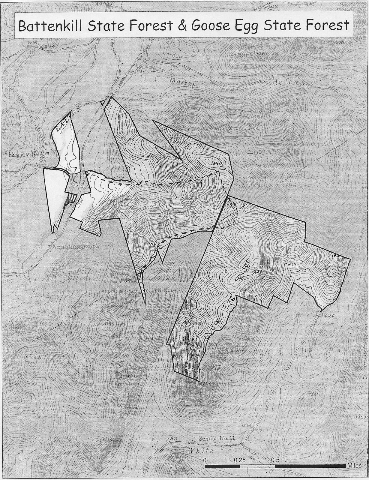
     The 535 acre state forest was created in 2000 with the purchase of the Bentley property. It's in the Town of Jackson between Cambridge and the Vermont border. Rt. 313 cuts through it with most of the acreage on the southeastern "hill" side and most of the use on the northwestern "river" side. The river, of course, is the Battenkill which slices thru the Taconics, then delineates part of the forest's boundary before meandering across Washington County to empty into the Hudson at Clarks Mills.
     State forests are managed for multiple-use objectives, including watershed protection, wildlife habitat, recreation and timber production. It should be noted that these lands are distinct from the forest preserve which is located within the Adirondack and Catskill State Parks. Washington County has both types of state lands with five state forests and the Carters Pond Wildlife Management Area to the south and large blocks of forest preserve in the northern towns of Fort Ann, Dresden and Putnam. There are also additional DEC lands near Whitehall that are outside the Adirondack Park. All of these are covered by Unit Management Plans with one being recently completed for the five state forests and Carters Pond.Several meetings were held at the Cambridge High School to gather public input. For maps and more information on the UMP try contacting Senior Forester Ben Thomas at the Warrensburg DEC office (518-623-1200).


     Before there was a state forest there was simply the river. It's been a part of my life for as long as I can remember. Swimming, of course, and a little paddling. Also this odd little endeavor I call hiking the Battenkill. Nothing more than wading downstream, floating the deeper holes, taking to the shore when I see a fisherman ahead that I don't want to disturb. The perfect way to spend a hot summer day - no tubes required. On the subject of fishing, sadly, I was born without the patience to do it. For me it's a spectator sport. I just love to watch the grace and skill of a good fly-caster in action.


     With the creation of the state forest came new ways to enjoy. I've run and skied and bushwhacked both along the river and in the high hills beyond 313. And there's no better place to launch long bike tours through out southern Washington County and into Vermont. When you come back hot and sweaty, the river is there to cool and soothe you.


     Lately (maybe advancing age has something to do with it) I can be happy just quietly studying the geology, botany, birds and wildlife. Sometimes simply relaxing by the river with a good book is enough. Picture an older couple who, after a life of passionate lovemaking, are content to sit on a park bench holding hands. You slow down but discover that it's not such a bad thing.
     But in my reading I've come across curiosities that begged for further investigation. Time to get back out there and poke around (however slowly). That's what I've been doing lately and I wanted to fill you in on what I've found.

     Let's begin with a dramatic introduction. From the hamlet side, in the Town of Salem, walk across the Eagleville Covered Bridge. Take in the smell of old wood and the softly echoing sounds of your footsteps. Watch the southern entrance grow from a little square of light at the end of a dark tunnel to a large frame for the landscape beyond. Most of what you see in that frame is the Battenkill State Forest. To the left is the river, to the right a copse of young trees and between them is the road leading your gaze up towards a high wooded ridge in the distance.


     The forest is somewhat disjointed, being sliced by Rt. 313 which runs from Cambridge east to Arlington, Vermont and then further bisected by the Eagleville Road between 313 and the bridge. Probably 99.9% of the areas activity occurs at the bridge and a parking spot just a few hundred feet up the road. The river is obviously the thing, much loved. Perhaps better words would be "lusted over". On hot summer days this can become quite the scene. Here epic tubing voyages begin, end and are celebrated while young women flash as much skin as the law allows and guys display their bravado with beer and vulgarities. But don't be discouraged. A simple check of your thermometer is all it takes. Sunny and above 85 degrees, leave it to the party people. The rest of the time is for us.
     From the parking pull-off on Eagleville Road a fisherman's path leads upstream. You can wander for a half-mile or so before coming to the Battenkill Lodge's private property. The bank here is lined with picturesque sycamores and cottonwoods. In summer it's lush with ferns and wildflowers. There are old river channels and traces of a dam associated with a large woolen mill which once dominated Eagleville. All that's left are a few foundations. Gifted photojournalist Grey Villet lived across the stream and the noted sportsman/writer Lee Wulff owned a swath of riverbank here. Now, a noted blogger pays taxes on a little chunk of it.


     Back at the parking area, look across the road where you'll notice a dense stand of young aspens, birch and scattered white pine. You're looking at controversy. This used to be a corn field until the state bought it fifteen years ago. The soils here are among the most fertile in the county - deep, level silt loams formed in flood plain alluvium. Many local people feel they should remain in production, but DEC decision makers obviously feel otherwise. While high input row crops such as corn may have a negative effect on the river, there are other options. The land could have been used for hay or alternately, offered to some young farmers for organic vegetable growing. Unfortunately, the current situation has fostered mistrust and animosity between the community and state managers.


     In any case, it's an opportunity to watch forest regeneration in action. Starting from bare ground less than twenty years ago you can observe what has developed to date and watch it evolve into the future.


     On the other side of the road to the east there seems to be some bush-hogging to maintain open areas while allowing other sections to revert to forest. Perhaps this is an attempt to create a variety of habitat types and edge environments that benefit diverse wildlife. This part of the state forest also holds an important site in the Philip Embury story of bringing the Methodist faith to America. Beyond Rt. 313 and high up the hillside is yet another interesting feature, an oak woodland of considerable ecological significance. We'll explore these in upcoming posts.

placebook -
     If this post's title sounds familiar, it's because I've just finished reading Norman Maclean's A River Runs Through It. For the third (or is it the fourth?) time. It's set in 1930's era western Montana, but it makes me think of the Battenkill. In 1992 Robert Redford turned the story into a movie starring Brad Pitt. I haven't seen the film but it's only been out for about 25 years. What's the rush? I'm more of a reading type guy and Maclean's writing is to be savored. The novella's opening and closing lines are literary gems. It's the tale of two brothers, the complicated web of emotions within a family and what we can and cannot do for one another. Rivers and fly-fishing are almost like characters in the book. The Big Blackfoot and the Elkhorn are the stages where Norman and his brother Paul's drama unspools. This is literature of place at its best. Hope you get to read it soon.


Sunday, February 21, 2016

Sunnyside Up

     Goose Egg State Forest is the poor stepchild of the five DEC units in southern Washington County. It's the smallest and it has no streams or wetlands. It's a little hard to find and there isn't really a trailhead - just a sign and enough space to park a couple of cars. Then you're on your own. Maybe that's why it's one of my favorite places. With a sense of adventure and a little effort you can have this island in the sky pretty much all to yourself.
     On a recent cold, clear February afternoon I spent a few hours exploring here and saw nary a sign of another person. There are several ways to access the forest but I like the approach from Cambridge Village out thru Ashgrove. The road twines with sparkling White Creek as it heads up valley. Just past the intersection with McKie Hollow Road you get your first look at Goose Egg Ridge, a striking wooded prow rising almost 1000 feet above the level of the stream. The road eventually crosses into Vermont and dead ends in Black Hole Hollow. I believe this is where the gravitational waves that have physicists in such a tizzy originate. Einstein would love it here.


     Fortunately you take a left onto Bates Road before disappearing into the Black Hole. Look for an impressive stone wall fronting a large white house, turn and head up the dirt road to its end. As you ascend look to your left to see your destination from a different angle. The ridge presents a steep side with the top looking like a camels back on steroids. There are four or five humps along its spine, the namesake goose eggs.


     After climbing Bates Road for a couple of miles you'll reach a snowplow turn around (don't even think of parking here!), several driveways (don't even consider blocking these!), a DEC sign and a woods road on the left. This is where you pull in and find a spot, ever thankful you spent those extra thousands for four wheel drive. Bates Road sort of continues on up the hill but any vehicle that doesn't want to end up in the emergency room should stop here.


     Writing a step by step trail guide is not on my "to do" list, so I'ld advise bringing a map and self-reliance. Since you'll probably want to get up on the ridge top, the trick is to find a route where the contour lines get a little breathing room between them, thus avoiding the wicked steepest slopes. I followed old skid roads up into a bowl, then climbed left for a mercifully short scramble to the first egg. On the way is an open hardwood forest laced with old stonewalls and sprinkled with gleaming chunks of quartz. Some of these white rocks are covered with dark green moss and the color contrast is striking. There are ledges of phyllite and a tiny trickle of cold water, one of many small headwater streams that feed White Creek.


     Once on top, take a minute to orient yourself. To the north and downslope a couple of hundred feet is the Folded Rock Trail. It starts from near the intersection of Rt. 313 and Eagleville Road. This is a longer, steeper alternative route with much more climbing. Some have suggested that the Folded Rock Trail be extended up and along Goose Egg Ridge. That would be OK, but really not necessary. The woods here are open and the walking easy with little chance of getting lost, trail or not.
     Turning south, you're looking down the length of the ridge. It's only a mile or so long and with all its eggs in a row there's a summit and dip pattern resembling a gentle roller coaster. You could think of the ridge as a canoe turned upside down, albeit one that has seen too much whitewater. Walk down the keel towards the narrowing bow at the far end. Don't go off either side or you'll tumblehome.
     There are low ledges exhibiting the typical, intensely folded pattern of Taconic rock. To the west is Snake Ridge, a little lower in elevation, and to the east are the higher peaks of Equinox, Red and Grass Mountains. The maple-ash-oak forest is pleasant if unspectacular. Surprisingly, when ecologist Neil Pederson cored  some of these trees he found individuals in the 200 to 300 year old range. They qualify as old growth, protected from logging by their inaccessibility.

Grass Mountain from Goose Egg Ridge

     Finally, there's a pleasing sense of anticipation and arrival as the ridge drops down to a crow's nest perched high above the White Creek valley. An attractive chunk of contorted ledge ceremoniously marks the spot. It's enough to give you goose bumps.  


Friday, February 12, 2016

World made by Kunstler

     Yin. Yang. Yawn. That, in a nutshell, is my winter reading routine. I have a cushy old chair beside the woodstove. A chunk of firewood stands upright next to the chair. It makes a perfect stand for my coffee cup. A couple of dogs snooze on the couch facing the stove. This is my nook and while it may sound idyllic, it's not without its challenges.
     After a cold day working outside it's heaven to settle into the chair with a hot drink, a good book and the fire crackling. The yin of comfort. But soon enough the warmth, relaxation and reading become a soporific yang. Eyelids get heavy, attention fades and my head nods. That's the yawn.
     But I'm made of stern stuff and do my best to cope with these hardships. Fortunately I've had help from James Howard Kunstler. He is the social critic and prolific author of a shelf-load of books. His canon has been the focus of my winter evenings and his disruptive ideas and engaging storytelling have helped keep me awake.


     Kunstler is probably best known for The Geography of Nowhere, a critique of what he calls our "crudscape". He takes acerbic aim at suburbia, sprawl and the tyranny of the automobile and often hits the mark. He followed up with Home from Nowhere, The Long Emergency and other works spotlighting problems of (and solutions to) our oil addled, car centric, technologic world.


Two sides of Greenwich - Big Box sprawl and a charming residential street

     He also writes fiction, including a post-apocalyptic World Made by Hand series of novels.There are three currently published with the fourth and final installment due out this spring. Read these and you might think you recognize some of the characters, almost as if they were your neighbors. And this is literally true since the story takes place in Washington County and the settings are only thinly veiled and slightly rearranged. Kunstler has lived in Schuylerville, Saratoga and Greenwich and he observes the local area and its people with telling perception.


The look and feel of World Made by Hand

     I'm sure Battenkill Books can get you any of the authors titles and you'll also find a smattering of his work in local libraries. He also maintains an interesting website. Check out his photo tour of Greenwich and the comments it elicits or follow the creation of his productive and inspiring backyard garden. There is his blog, podcasts, "the eyesore of the month" and, surprisingly, a gallery of his paintings. The guy is a torrent of ideas and creativity and you can see this firsthand at North Main Gallery in Salem. They are hosting an exhibition of his art with an opening reception on Saturday, February 13 from 2 - 5pm. Combine this with a visit to Steininger's or Jocko's and you've put life, color and taste into the dead of winter! 


Place at the Table - Washington Square Deli


                                                                                                                                                                          If you decide to do a walking tour of Greenwich, as Kunstler does on his website, you're going to work up an appetite. I'ld recommend a stop at the Washington Square Deli for their selection of homemade soups, chili, subs and sandwiches. They always have lunch and dinner specials and the antique ambience of their cozy dining area adds to the enjoyment of your meal. Plus you'll be sitting within sight of their dessert counter! We often stop in for road trip provisions when exploring southern Washington County. Great way to start or finish an outing.

Thursday, February 11, 2016

Mind your Minerals

     Remember the last time somebody said to you, "You're a real gem"? Well, me neither. But, just in case such a compliment comes our way (and it should!), here's the definition. A gem is any mineral prized for its beauty and rarity, usually enhanced by cutting and polishing. Of course, this begs the question, "What's a mineral?" And the answer is: a naturally occurring solid with a specific chemical composition and a distinctive internal crystal structure. This structure is controlled at the atomic level by a particular, repeating three-dimensional pattern and seen externally as flat faces arranged in geometric forms.
     Now that I've got you thoroughly confused I'd like to recommend a trip to this weekends Gem, Mineral and Fossil Show and Sale  at the New York State Museum in Albany. There you'll see displays of both natural and faceted minerals in shapes and colors that astound. Plus, you can talk to people who really know what crystals, minerals and gems are. Let's not forget about fossils. There'll be lots of those as well. Admission is five dollars with specimens for sale from down to earth to the sky's the limit.


     Leave enough time to tour the museum where there's an amazing display of New York State minerals along with other exhibits on geology and a host of natural, historical and cultural aspects of the Empire State.
     Unfortunately, Washington County seems to be the Rodney Dangerfield of the neighborhood when it comes to minerals. So little respect that I remember only one measly item from here in the museum's huge collection. And that lone piece wasn't particularly impressive. It's St. Lawrence County that gets most of the glory but Essex, Warren and even Saratoga Counties seem to have a richer bounty.


     Given that I don't know much about minerals and Washington County isn't over-endowed, I should probably sit down and shut up. But what fun would that be, so here are a few suggestions. You can see garnets embedded in the gneisses of the Lake George mountains. Most are small but they're still fun to find. Pegmatites are fairly common and sometimes yield nice specimens. These are course grained intrusions that can be found in veins cutting thru bedrock. They originate from magma with a fair amount of water in it. As the fluids cool, crystals sometimes grow. There is a striking pink pegmatite in a road cut along Rt. 22 in Dresden. It diagonals up the face from ground level and is easy to examine. These type of rocks were also quarried (over a hundred years ago) off of West Road in Fort Ann. The feldspars and quartz's mined here were used in pottery making.


     Graphite used to be mined on the west side of South Bay and magnetite in Fort Ann up by Lake Nebo. There may be other minerals associated with these digs. There are also reports of gravels cemented with calcite crystals from pits in Putnam. The problem is that all of these sites are private and posted.
     Further east in the Taconics, phyllite and slates are  found and they sometimes contain veins of quartz and "ringer" inclusions. You might also find porphyroblasts with crystals of various minerals. Even the shales of the Hudson/Champlain lowlands can surprise. In my farm shale pit I've broke out small cavities with nice quartz crystals growing inside.


     Fossils will be located mostly in the limestones between the Taconics and Adirondacks. I've seen stromatilites, snails and bivalve shells. Better to just look at these and leave them in place for others to enjoy. I know that plain old rocks (a naturally occurring and coherent aggregate of one or more minerals) aren't as sexy as crystals and fossils but Washington County has a nice variety and in collecting these you'll learn about the regions fascinating geologic history. As the saying goes, "The Lord must love common people because he made so many of them." And common rocks, I might add.

Digging Deeper
     - Capital District Mineral Club
     - Burlington Gem and Mineral Club


Sunday, February 7, 2016

Stormy History

     I've always been a little foggy when it comes to history. Dates, events and famous people - they don't really do it for me. I'm more of a "places" type of guy. When I stumble upon an old foundation in the woods or the overgrown trace of a trolley line or canal, I want to find out more about it. I want to know its history. Maybe it's a reaction to the "Blah, blah, blah" boredom of high school classes but I like things that are tangible and concrete, things that you can walk up to and touch. Real places offer the pleasure of discovery and incentive to learn more.


     Last Wednesday was a foggy, rainy winter day but I decided to ignore the gloom and go looking for local history. My first stop was the Wing-Northup House on Broadway in Fort Edward. It's a beautiful old structure somewhat lost in its setback between rows of commercial storefronts. This is the home of the Washington County Historical Society, open on Wednesdays and Fridays. To the right of the center hall entrance is the Heritage Research Library. It's most often used for genealogy work. My interests lay in Charles and Gaynelle Moore's monumental documentation of all the cemeteries in Washington County.


     After finding my information I walked across the hall to a room where the Society operates a small bookstore. Talk about your "kid in a candy store". I always have trouble staying within my budget here. Today I managed to limit myself to Argyle 1764 - 2014, recently published by the Argyle Historian's Office. As soon as my piggybank fills up I'll be back. This place is a treasure trove for Washington County enthusiasts and your purchases support a great organization.
     The WCHS is dedicated to education about and preservation of our regional heritage. They sponsor lectures, tours and workshops and also publish books, an annual journal and newsletters. On their website you'll find contact information for town and county historians and local libraries plus a full list of publications for sale. Find out more here.


     After my visit to the Historical Society I drove up River Street to take in the view of the Hudson and Rogers Island - quite moody and mysterious in the rain and fog. Then it was thru Hudson Falls and on towards Glens Falls.  Whenever I pass this way Kendall McKernon's photographs come to mind. Wish I could borrow just a little bit of his talent!


     At Crandall Library I went down to the Holden Collection to check out the 1853 Morris Levey map, wondering if it showed a cemetery and house I was interested in. Then I surveyed their extensive collection of Washington County books and spent some pleasant time browsing Cambridge and Argyle histories. This turned up several areas I want to visit in the future including the Allen family massacre location as well as mill sites on Flax Mill Brook and Pumpkin Hook Creek. This is sort of the flip side of what I mentioned earlier, where you first read about a place and its history, then try to see if you can find it.


     Upstairs I picked up a few items including a compact audio disc in the Great Courses series entitled Big History with Professor David Christian. This is an interesting new concept in teaching the past that starts at the very beginning with the Big Bang and the creation of the universe. It proceeds thru the formation of stars and planets, chronicling Earth's development and the origins of life. Finally, about halfway thru the lectures, the evolution of hominids is introduced, including one that is usually the sole subject of history courses. Under the umbrella of big history we watch cosmology, geology and biology set the stage for our antics. The human story told here is more about major trends and concepts than specific dates and events. It has a wholistic, all encompassing feel that's more satisfying than typical presentations focused on a particular nation or time period.

13.7 billion years in 48 lectures

     So here's your homework. Pick a favorite spot - could be your home, the town where you live, or a patch of wilderness - and let your curiosity out of the closet. Where did the atoms that make up this place come from? How and when did they assemble to make what you see? What forces shaped the bedrock landscape? How about the atmosphere above with its climate and weather? What kind of plant and animal communities have developed? And finally, what have people done here, be they Native Americans, European colonists or your closest ancestors?
     Don't worry, you have the rest of your life to work on this and there won't be a test. Plus you've got lots of helpful resources - people and organizations, books and websites. Hopefully the assignment will clear up some fog and bring your relationship with place into focus. Bet that's more than you got out of your high school history class.

Sky and Telescope diagram
A "Cool" Family Reunion
     Finally, a clear (and cold) morning. I went out about 6am Saturday hoping to view five planets and got more than I bargained for. Jupiter was the leader of the pack - unmistakably the brightest thing in the sky high in the west. Mars and Saturn took a little searching. They're dimmer and lie amongst stars of similar magnitude. It helps if you recognize the outlines of the constellations. Then you can spot something that looks out of place. Remember, the constellations you see just before dawn in winter are the same ones visible early on summer evenings.
     Mars was about halfway up from the horizon looking south, lying between Spica to the west and Antares to the east. It was just a little bit brighter than those two stars and glowed with a steady orange color compared to their stellar twinkly whiteness.  Saturn was further east beyond Antares and the constellation Scorpius. It's usually described as having a golden color. Now's an opportunity to compare it to Mars and see if you can detect a difference in their tints. If you've got a telescope it's also a good time to see the tilted rings in all their glory. Beyond Saturn the sky was beginning to lighten with approaching dawn. Still, Venus was easy to spot, just a little above the horizon. Its magnitude is actually greater than Jupiter's but it doesn't appear as striking because the sky here isn't as dark. An extra treat was a slender fingernail Moon just to the left of the planet.
     But what about elusive Mercury, never far from the Sun and always a challenge to see? I was getting cold, there were some low clouds resting on the eastern hills and a few trees blocked the view as well. So naturally I cheated, using binoculars to scan below the Moon till I found it. Just a tiny shining spec peeking over the clouds. Once located I could see it with just my eyes, but barely. By then hypothermia was setting in so it was back inside to thaw out under the covers for a little bit before chore time. Hope we have clear (and warmer) mornings the next few days so you can catch the show.

* Just can't get out of bed that early? Check out photos here and here.