Friday, March 25, 2016

Ekwanok on the equinox

     Thoughtful of them. To place a mountain such that the sun rises perfectly over the summit on the first day of spring. To call it Mt. Equinox.
     Now it's important to know that I have a very difficult life. Hardships befall on a daily basis, forcing me to whine and complain to my long-suffering wife. But rather than getting the sympathy I need and deserve, she usually responds with "We're so lucky" and a long litany of all our blessings - good food we grew ourselves, a roof over our head, dogs and cat, a kid that's not on probation or in rehab - things like that. Of course, I have to reluctantly agree. What choice do I have? So once I come over to the sunny side I count the views from our farm as one of the many things I'm grateful for.
     From my fields I look across the Hudson Valley to hills that sweep from above Argyle past the double humps of Bald Mountain to ski-sloped Willard. Beyond this facade are more and higher hills, like a rumpled, unmade bed culminating in the big pillow mountains of the far horizon - Mt. Antone and Bear to the north, Red and Grass to the south and due east, overseeing all others, Mt. Equinox, like a queen reigning over her court.

Bald Mountain

Willard Mountain

     At 3816 feet, Equinox is the highest point in the Taconic Range. It's a familiar presence thru out central and southern Washington County. For eye catching open vistas try Christie, Shields or Stanton Roads. Irish Lane and up by the firetower on Mt. Colfax also have good views. Its profile changes depending on your vantage point but from our farm there are north and south shoulders rising to a cone shaped summit. Symmetrical and pleasing, just the way a mountain should look.

Mt. Equinox from Irish Lane

     I first climbed it many years ago, going up from Manchester on the Burr and Burton trail. Young and fit, used to doing Adirondack peaks, even then I remember thinking "This is a steep sucker." The trail received little maintenance and in places seemed like a bushwhack. When I finally popped out of the firs and spruces to a huge parking lot and hotel, to cars and tourists, it was all a little surreal.

Tourists at Lookout Rock - from Mt. Equinox website

     Years later I convinced Gwenne to "go for a little hike" up Equinox. This would have been fine if she hadn't been eight months pregnant at the time. A month later I talked her into canoeing on the Battenkill and the next day she brought Holly into the world. Did I mention my long-suffering wife?


     I've skied to the summit going up from Three Maple Drive to the Beartown Wind Gap and then following an old carriage road along the north ridge. I'm no extreme skier and this route was surprisingly easy in a good snow year. Not so easy was a footrace they used to stage on the 5.2 mile Skyline Drive. I remember it taking just under an hour. A searingly memorable hour. Limping across the finish line I was handed a loaf of bread by the guy who had won the race - I believe his name might have been Matthew Cull. A thin, bearded guy who seemed to float up mountains to offer bread to those who followed him. Hmmm...


     Now days I'm more likely to do a little botanizing  on the Equinox Preservation Trust trails. These are a network of paths adjacent to Manchester. The mountains unique geology with a base of marbles and limestones capped by more resistant phyllites and graywacks creates lush growth and a profusion of wildflowers. This is also fertile ground for conservation projects. While the Carthusians own much of Equinox, groups such as the Nature Conservancy, the Vermont Land Trust, the Equinox Preservation Trust and others have protected large tracts and there are dreams of a continuous green belt from here north to Merck Forest.

Deer Knoll

Equinox Pond - Photos from Equinox Preservation Trust site

     Now back to my tough life. I was feeding the cows around seven Sunday morning, snatched from a warm bed by the demands of farming. It was clear and cold as I made several circuits with the skid-steer from bunker silo to feed bunk. With each trip I watched the approaching dawn brighten the horizon. Finally, on the last lap the sun popped up directly over the top of Mt. Equinox on the vernal equinox. I felt like jumping out of the machine and cheering (but refrained... the neighbors already think I'm crazy).


     Serendipity. How else can you describe it? The mountain wasn't named for the equinox but rather from the Native word "Ekwanok" which translates as "the top". Besides, only a few people along a narrow line of sight would experience the sunrise phenomenon. But there are other lines of sight, other phenomenon. Every place has the potential to surprise and delight if we're open to it. As someone once said to me, "We're so lucky."

All things being Equinox

     I haven't been on the mountain in a few years so this post relies on memories. For up to date information check out these sites:
     - A fellow blogger describes her recent hike up Equinox at Nooks and Vales.
     - To learn more about the Equinox Preservation Trust and their trails click here.
     - The Nature Conservancy's Equinox Highland preserve's website has good information.
     - Find out more about the Carthusians and their monastery on Equinox.
     - History of the mountains development and Skyline Drive information here.
     - If you need an outlet for your frustrations Manchester's certainly got enough of them. It's a little over commercialized but most people are going to do something in town during a visit to Equinox. Up for Breakfast, Mother Myricks, the Northshire and the Mountain Goat are all popular stops. The Chamber of Commerce site has lots more suggestions. 

     - Here's a few photos from the Carthusians' website. The monastery is located on the west side of the mountain near Sandgate. It is not open to the public. Please honor their desire for solitude.
 
Aerial view of the mountain looking north


Lake Madeleine and the monastery 


The monastery


The monastery in summer

The Monastery with Equinox in background


Monastery gardens


Carthusians' Visitors Center on summit of Mt. Equinox


Friday, March 18, 2016

Egg Mountain Lost and Found

     Rain and rebellion were in the air. In this strange, snowless winter, warmth and precipitation have this little hook-up thing going. Maybe it's El Nino playing Cupid.  Balmy, drizzily days have begun to feel normal. And what about the rebellion? You'd think we're in for one given the ranting promise of change that we're bombarded with this election season. But the rebellion that interests me happened well over two hundred years ago and the rebels really did "build a wall". Actually, they built lots of walls that are just now being discovered and excavated up on Egg Mountain. It's a great story.


     I was in Salem to hear Steven Butz talk about the Shays Settlement Project. He gave his lecture at the Courthouse Community Center to a standing room only crowd. That so many people turned out on a drenched and foggy night is testament to the fascinating work Butz is doing.


     Do you remember Shays Rebellion? Well, neither did I. The day it was covered in American History was probably one of many I spent skipping school. So here's the refresher we both need: Captain Daniel Shays was a Revolutionary War hero, trusted by General George Washington and befriended by LaFayette. When the Continental Army veteran returned to his western Massachusetts home he was penniless and besieged with high taxes. He wasn't alone. Other poor farmers were being jailed and having their property seized because they didn't have the cash to meet onerous tax obligations. There was a class divide component to the situation with wealthy Boston merchants and their political puppets pushing for hard currency tax collection from the farmers who operated in more of a barter economy.
     A series of conflicts culminated in Shays leading a militia that closed down courts and marched on the government armory in Springfield. They were meet by a privately raised force, there were shots fired and fatalities. Despite honest grievances, things went badly for the rebellion which eventually fell apart. Shays and some of his followers, facing arrest and probable hanging, fled to shelter in the woods of the independent republic of Vermont.
     Ah, but where in Vermont? Well, a great deal of evidence points to Egg Mountain. If you can't remember skiing or hiking on Egg Mountain there's a good reason. It's a privately owned, trail-less, relatively inaccessible peak that's around 2500 feet high. It's not in the iconic Green Mountains. Instead, it's part of the Taconic Range along the New York-Vermont border and there it gets overshadowed by higher mountains such as Bear, Mother Myrick and Equinox which rise just to its east. If you were to climb it, the most likely approach would be from near Salem in Washington County.


     That's how Steven Butz was introduced to it when a friend took him on snowmobile up to the "Fort" many years ago.  Locals have long known of the "Fort", an enigmatic 100 by 100 foot stone foundation structure on a southern shoulder of Egg Mountain. I wish I could tell you I've been up there and describe it but the truth is, I'm not sure.
     There's a confusing jumble of terrain between Salem and Manchester, Vermont that's both beckoning and also forbidding. It forms the eastern horizon from my fields so these ridges seem to be constantly taunting me to climb them. But the only public trails I'm aware of are the ones on the east slope of Mt. Equinox and the network that Merck Forest maintains above Rupert. For a great view of this rugged country climb up thru the sculpture park to the top of Cary Hill at the Salem Art Works.


     You can explore here on narrow dirt roads like the one that goes from West Rupert thru Kent Hollow and Sandgate to (maybe) return you to civilization at West Arlington. This is definitely not recommended during mud season but it is the way I have used to climb Bear Mountain and other peaks. That was a long time ago, before the POSTED sign industry hit its stride. Back then it seemed a little easier to just poke around. Now it's No Trespassing everywhere, hard to even stop and examine a roadside rock outcrop, let alone wander the woods. The truth is I don't have photos, notes or clear memories of Egg Mountain so I can't be sure I've been up there.
     Fortunately, Steven Butz does have photos and notes. Lot's of them. As he recounted at the lecture, he never forgot that early trip to the "Fort". Eventually he did some research and got permission to do archaeology. The Shays Settlement Project was born.


     For a few years now Butz has spent the summers excavating and teaching with students from Cambridge Central School. They have uncovered nine sites and a large quantity of artifacts. Foundations, collapsed chimneys, a well and related structures spread over more than 300 acres of hillside. Nails, tools, glass, ceramics, buttons and a coin have been found. There's also a possible burial site. It appears that the settlement was occupied for less than thirty years, although Shays himself was only there for a couple of years. Apparently there was an epidemic, the mountain was abandoned and all the buildings were burned.


     For archaeologists and historians this is exciting stuff. But perhaps the greatest impact of the Shays Settlement Project will be on the kids who've worked up there. They are discovering the rich legacy that surrounds them while doing hands-on science, getting dirty and, I suspect, having a lot of fun. The project seems like its own small rebellion against an education system infected with too many tests and too much institutionalized homogenization. Our kids are better off in the hands of parents and caring teachers rather than under the control of politicians, bureaucrats and administrators.


     The Cambridge/Salem area is fortunate to have people who know and care about the place they call home and who generously share with the community. I'm thinking of Steven Butz, Howard Romack, Sue Van Hook, Jerry Jenkins, Sally Brillion, Ken Gottry, Al Cormier and many others. They are a valued part of the quality of life in Washington County.

Digging Deeper

     - For lots more photos and information on The Shays Settlement Project check out their facebook page.

     - Butz wrote an article for the 2015 Washington County Historical Society Annual Journal entitled Shays' Rebellion Comes to New York. Get a copy at their Fort Edward headquarters or from their website.

     - The Forest Land Group owns the land where the site is located. Butz says they have been great to work with, granting access and financially supporting the project. There are questions about who can visit the dig, what will happen to the artifacts found there and the ultimate fate of Shays' Settlement. Hopefully some of the discoveries will be displayed in the public spaces of surrounding communities - libraries or town halls in Salem, Sandgate and West Rupert. I'ld love to see a trail leading to the site and on to the summit of Egg Mountain. With interpretational signs this would be a valuable addition to the area's historical and recreational assets. Maybe someday, but for now remember that this is private property and a sensitive archaeological resource that shouldn't be disturbed. 


     - For those who want to learn more about archaeology in the Capital Region there's the Auringer Seelye Chapter of the New York State Archaeology Association. They have meetings and speakers at the Saratoga Library. Find out more here.


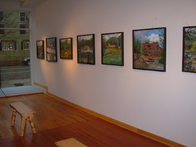
     - The Courthouse Community Center on East Broadway hosted the lecture. It was one of several March History Talks. For researchers there are valuable Town of Salem archives here and at Bancroft Public Library. You can also connect with Town Historian Al Cormier thru them. The main hall functions as an art gallery with still lifes and landscapes by Virginia Lynn Anderson currently on exhibit. Very nice. Find out more about the Courthouse here.


     - While in Salem I took in the James Howard Kunstler show at North Main Gallery. In this agrarian area many artists choose rural landscapes and old barns for subject matter. Not Kunstler. Ever the contrarian, his paintings often depict abandon mill sites and transportation infrastructure that's seen better days. I believe the show is down now but you can see his work at James Howard Kunstler. Next up at North Main is Stu Eichel's "Elegies in Oil" of cars rusting back into the earth from which they came. I wonder if Eichel and Kunstler have lunch together?


     - All along the eastern border of Washington County are dirt roads that follow small streams up into hollows. Some manage to crest ridges and connect to roads in Vermont. Many simply peter out into dead ends. It can be hard to know which state you're in. Here's a tip: if you want to give them Hill, you're probably in New York. If you feel the Bern chances are you've crossed into Vermont. And if you sense you're about to be Trumped you're in Deep Trouble. Another way is to look for stone monuments placed on the border near road crossings. They're a little hard to see, being neither red nor blue but just a dull gray.
     This area marks a somewhat arbitrary boundary between the High Taconics to the east and the Low Taconics to the west. The Taconic Range was created by plate collisions that pushed large chunks of rock from the sea floor up onto the edge of ancient North America. The rock moved on thrust faults, sliding in gigantic slices one against another. The remnants of one of these thrust faults lies just east of Salem and is marked by a change from slatey rocks on the west side to more metamorphosed phyllites to the east. There's also a jump in elevation above the fault scarp.


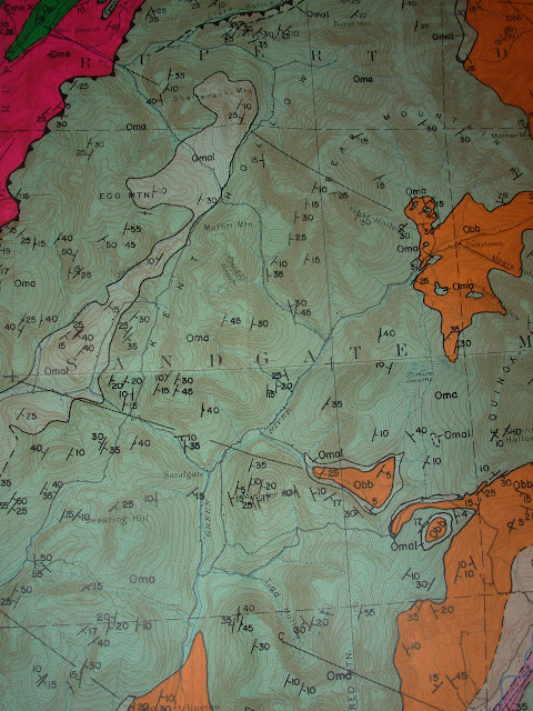
     Dry Creek, Buttermilk Falls Brook and Blind Buck Stream are three small tributaries of White Creek which flow off Egg Mountain and adjacent ridges. Each has a road leading up into the hollow they have eroded into the mountains. Chambers Road follows Dry Creek and you can visit the sugar house here over the next few weekends. Beattie Hollow is at the head of the Buttermilk Falls drainage and is the current access to the Shays Settlement. I heard my first spring peepers in a small pond here on March 10. Blind Buck has a web of side roads with permanent residences and seasonal getaways. This may be the way Shays originally approached Egg Mountain. All are good for quiet (uphill) biking and back road running.

     - The theme song for this post has to be Volunteers by Jefferson Airplane. Google it and watch the live version from Woodstock. Idealism! Rock'n Roll! Grace Slick! If Shays' Rebellion had Volunteers for an anthem things might have turned out different. And if the next revolution is crushed as well, I know this little mountain near Salem where the volunteers could hide.


Sunday, March 13, 2016

Short Ears and Tall Grass

     People were gesturing excitedly.
     "There he is!"
     "Wow, he's feisty."
     "Look at him go after that guy."
     Donald Trump at a Republican debate? No, this confrontation was much more civil. Short-eared owls were sorting out territorial rights with marauding northern harriers and with each other. And we had ring-side seats to the action.
     Gwenne and I had joined the ADK Tuesday group for a few hours of birding in the Fort Edward grasslands. We were fortunate to have Laurie LaFond as our guide. She's an expert birder and has long championed preservation of the open fields found where the Hudson/Champlain Valley squeaks between the Taconics in the east and the Adirondack foothills to the west.


     The group gathered at the Little Theater on the Farm where we introduced ourselves and got some initial orientation. Then we walked out in back of the barn past the frozen pond thru snowless fields. There's a great deal of open hay ground in the area, most of it short-clipped stubble. Laurie explained that it would be better for birds if alternating strips were mowed on a three year cycle. That way there would be more and taller cover but it wouldn't revert to brush and woods. Unfortunately, this is impractical for farmers. I cut my fields three or four times in a season. Good for hay production, not so good for birds. There are programs that pay landowners to manage in a more bird friendly way and they may be part of the solution.


     Our next stop was the Wildlife Management Area on Black House Road near the intersection with Co. 46. Look for a DEC sign, a parking area and an information kiosk. Walking down a lane on the east side of the property leads to an observation platform. The path is lined with white oaks and shagbark hickories. Off to the left (on private property) is the site of the Vita Spring. In the late 1800's mineral water was bottled here and the spring was a popular spot for picnics and gatherings.
A little further on someone has placed a rustic bench made from an intricately weathered slab of limestone.


     From the platform we saw a red tailed hawk perched and a northern harrier swooping low. There was a distant flock of geese, long parades of crows and a couple of tight clusters of starlings and red wing blackbirds (Laurie's best guess). Birds weren't the only thing in the sky - we saw a couple of nice sundogs as the day wound down.


     This area was once at the bottom of glacial Lake Albany. The fine sediments that settled out of the meltwater became the clay soils we find today. After the lake drained, its flat bed was dissected by run-off producing the modern landscape. Little trickles that you can hop across make their way to Dead Creek which flows (just barely) into the Moses Kill, a tributary of the Hudson.


     Silty clay soils have low permeability and are often wet in spring and fall. This makes them better suited to perennial hay crops than annuals such as corn which requires early season tillage and planting and late season harvest. The result is a grass based agriculture which features large open hay fields. Over time this landscape has been whittled by residential development and farm abandonment.
If the hay is not cut or grazed it gradually reverts to brush and then trees.
     This grass ecosystem is habitat for large numbers of small mammals (think meadow voles) which are choice menu items for birds of prey (think hawks and owls). Many other bird species are attracted to meadow/grassland environments for breeding and nesting. The list includes: Upland Sandpiper, Eastern Meadowlark, Bobolink, Bluebird, Sedge Wren and Savannah Sparrow. These are the factors that led Audubon to designate the grasslands as an Important Bird Area. By some estimates there are 13000 acres of open land in central Washington County with about 2000 acres forming the core IBA. Of this just several hundred acres are protected and managed.

Meadow Vole

     With an amicable gathering of like-minded people there was plenty of socializing and relaxed lollygagging. Maybe too much, especially by yours truly. They don't let me off my leash very often and the result is a need to look at everything and talk to everybody. But Laurie knew that with the sun sinking towards West Mountain, the grand finale was about to take the stage. We left the DEC area and quickly carpooled over to a ridge-top location on Co. 42. Here the Friends of the IBA have received a gift of property from the Loftus family and plan to build a viewing area. From this vantage you look down into the mixed shrub and grass of the Dead Creek Valley. Ideal Short-eared Owl habitat and there they were!


Gordon Ellmers photo of Northern Harrier

     As dusk settled we were treated to quite a show. Experienced birders said they saw five owls and a couple of Harriers stirring things up. The birds did some flashy aerial maneuvers showing the light undersides of their wings. I often see Northern Harriers in their swooping, gliding low to the ground flight over my hay fields. They are fun to watch and easily identified by the white rump patch and long tail. Short-eared Owls aren't seen as frequently. There are fewer of them and they are only here at the grasslands in a few locations during the winter. The best time to watch for them is just before dark when they become active.

Gordon Ellmers photo of Short-eared owl

     The future of the Washington County grasslands seems uncertain at best. It's hard to reconcile profitable farming practices with bird habitat conservation. In any case, the farming seems as endangered as the owls. Building lots are octopussing out along every road. Sprawlscape is the term James Howard Kunstler uses in The Geography of Nowhere. What's needed is large scale land acquisition and management but that seems unlikely.
     It sort of reminds me of the decision to have children. You know it will be costly and involve some sacrifice but also that the rewards are well worth it. So it is with birds. Are we willing to bear the cost for the rewards of having them here? I don't know the answer to that but I do know I'm grateful for the dedication and hard work of the Friends of the IBA. And I know it's way more fun to watch hawks and owls than bickering republicans and democrats.

Laurie LaFond photo from Fiba's website

Grazing the Grasslands

 - The Friends of the IBA are a great organization that deserves your support. They have an upcoming bird walk on Saturday, March 19. Find out more here.
 - FIBA's big event of the year is Raptor Fest held this year at the Washington County Fairgrounds on May 14 & 15.
 - Audubon designates IBA's and the local chapter is very active with programs, outings and conservation efforts. Visit Southern Adirondack Audubon's website here.
 - Dr. Gorden Ellmers takes great bird photos, many of them in the grasslands. Take a look here.
 - DEC has maps and species profiles at their website.

River Road and the Hudson

 - It's easy to combine the grasslands and the Hudson in one outing. The river in spring is full of waterfowl and there are eagles and osprey as well. Holly was running on River Road recently and passed right under two eagles perched in a tree. As the season progresses check out Denton Preserve and the Towpath along the old canal out of Fort Edward - both are birding hot spots.


Little theater on the Farm
Fred Wehner photo
 - Little Theater on the Farm is in the center of the grasslands. It's a great place for music and entertainment. Check out their 2016 schedule here.

Place at the Table - Mandy's

     The owls begin feeding at dusk, hunting for meadow voles into the evening. I'm usually ready to eat anytime although I don't have a taste for voles. Pizza is more to my liking and after it got too dark for birding our friends, Steve and Licia, suggested we stop at Mandy's to enjoy some. Great idea!
     Mandy's is a small, family owned place on the corner of Burgoyne Avenue and Schuyler Street in Hudson Falls. They're famous for their finger rolls but they also have delicious subs and pizza. Whenever we're headed up to the east side of Lake George or anyplace to the north we stop in for a couple of subs to fuel our adventures. Most people order and take out but there are a few tables for dining and the menu goes beyond the basics. Highly recommended.


Wednesday, March 9, 2016

Summit/Soup

     There's this blogger I know and trust. He recommended climbing Haystack and then attending First Friday in Granville (TGIF). Sounded like good advice so that's what we did.
     Haystack is a much loved local landmark in the Mettawee Valley just north of Pawlet Vermont. It's so popular it has its own facebook page. Because its rocky pointed peak is so prominent, people have always felt the urge to be up there. I used to visit with the farmers at its base and then scramble up the front. There was an oft-used herd path on the back side but I didn't have a clue.

Haystack ahead

     The Nature Conservancy, the Vermont Land Trust and the Friends of Haystack have all been active in conservation efforts here. Protected lands on the high ridge to the east of Rt. 30 are called the North Pawlet Hills Natural Area and are home to peregrine falcon, bobcat and bear. There are rare and endangered plants and uncommon ecological communities. And there is the wild topography with parallel strings of north-south trending hills like pearls in a necklace. Haystack is at the southern end of one such chain. Along with Middle Mountain and Bald Hill it is one of the Three Sisters. Viewed from Wells near Lake St. Catherine, this upland area presents a striking line of west facing cliffs, the scarp of a thrust fault.


     To hike the mountain turn off Rt. 30 onto Waite Hill Road. In about a mile look for Tunket Road, a dirt lane leading uphill on the left. Don't drive up but do pull off Waite Hill without blocking access to the lane, fields or silage pile across the road. Walk up Tunket a half mile to a TNC trailhead on the left.


     The road has been here since the 1700's and it used to be a lot busier. In the 1800's there was a bustling settlement in the hollow between the Three Sisters and Fox Cobble. I wonder if all the kids made the reluctant trek down to the Spanktown School? Maybe some did but not for long. By the early 1900's Tunket was an abandoned ghost town. Today beef cattle graze, the maples get tapped and a few people homestead off the grid. There's an interesting local connection in that Brian and Justine Denison once owned land here. They currently operate the Denison Farm in Schaghticoke and many in southern Washington County and beyond purchase CSA shares with them. Part of their former Pawlet property was added to the Natural Area and part became the Laughing Child Farm, which grows sweet potatoes.


     The trail starts in piney woods that seem to be overgrown pasture. Look for two large maples that surely predate the evergreens. You go up and down a little, rock hopping a couple of small streams, before beginning a steady climb thru hardwood forest towards a col between Haystack and Middle Mountain. The rock is a wavy, greenish phyllite with several large boulders that may have been plucked and placed by the glaciers.

A Chilling Sight


     Eventually the way becomes quite steep, grazing a hemlock ravine and winding thru thinning scrubby woods till there are no trees at all - just bare rock, views in every direction and a sense of fellowship with those who've come before seeking respite, rejuvenation, exultation.


     After Haystack we drove along the Mettawee and thru the slate quarries to West Pawlet where we stopped at Wayfaring Goose Farm. Spent a few pleasant minutes with Dan and his jersey girls before it was time to head up to Granville and the Slate Valley Museum for a "soups on" First Friday. There were five steaming crock pots representing the ethnic diversity of the quarry workers and their families - Irish Stew, Italian Wedding soup, Welch potato and leek, Jewish Matzah Ball and Slovakian mushroom. Naturally I sampled all of them.
     A Haystack appetizer and soup for supper - what a tasty combination!