Thursday, August 25, 2022

Span-A-Lot

     First an origin story, then a final look at some of Washington County's lost spans: 

     Crawling along on all fours she suddenly came face to face with a snake. Startled, she sprang up on her hind legs and started to run. Pleased that standing upright helped her escape snakes (and obnoxious male members of her own species) she stuck with the two leg thing. So did her ancestors. They found that the new stance could take them far. But water crossings always proved troublesome. Speedos and the Australian Crawl hadn't been invented yet.

     A few eons later her descendent stood on the bank of a stream eyeing the berries on the other side. She wanted them but didn't relish the cold dunking required to get there. Gave her goose-bumps just thinking about it. Fortunately she had inherited the 'find a better way' gene. She scoped the situation and mused "Maybe ... just maybe ..."

     Summing a couple of males from the tribe (useful for their brute strength, if nothing else) she directed them to roll a fallen log into the water where the current swung it around till it jammed from bank to bank. You can guess who scooted across that first bridge and got to the berries first. And while she was slurping them down she kept picturing that log rolling towards the stream. That's when it came to her: "Might as well invent the wheel while I'm at it."

     Because she wanted those berries (but didn't want to get wet) we now have lots of wheels and lots of bridges. So many bridges that some of the early ones have been abandoned. Call them 'ghost bridges' and in this third in a series post we'll look at a few more.

     Last time, we shared an illustration of Burgoyne's 'bridge of boats' that he used to get his army across the Hudson. Apparently this wasn't the only floating bridge from those days. Old maps show another near the American camp area of the Saratoga Battlefield. It connected the west (Saratoga County) side with what is now Washington Counties' southwestern corner in the Town of Easton. It was located just downstream from where Mill Creek joins the Hudson at about the spot where present day Rt. 4 approaches the river in the Town of Stillwater, Saratoga County. I doubt if there is any remaining physical evidence of this span but it would be interesting to talk to rangers and historians from the Battlefield Park who may have more information about it. 


     A still earlier pontoon bridge turns up on maps from the 1750's. It crossed the Hudson just south of Roger's Island running from the west side to a point in the Town of Fort Edward where Lock 7 of the Barge Canal is now located. It was part of the military road that came up from Albany to Fort Edward and then went on to Lake George.  


D marks location of 'Ponton Bridge' downstream from Rogers Island


Looking across Hudson River from entrance to Lock 7 of canal,
approximate location of 1750's 'Ponton Bridge'

      Another of the early military bridges was located just north of Washington County. Built in 1776-1777 across a narrow section of Lake Champlain, it connected Fort Ticonderoga with Mount Independence in Vermont. This one didn't float. Soldiers built at least twenty caissons (piers) and pushed them onto the ice in winter. Come spring they sank to the lake bed. Boards were laid from one to the other and anyone brave enough could walk from one side of the lake to the other! The brave (or foolish) can still scuba dive down to them in Champlain's murky waters.


Fort Ti at top, Mount Independence at bottom with bridge marked X


This cutaway illustration shows the caissons with the overlaid plank walkway and a lone soldier


     Better known are the County's beloved covered bridges. Three are still carrying traffic while another is used as a museum. Many more have been lost. For anyone interested in these engineering marvels, their location and history, I highly recommend Robert McIntosh's The Covered Bridges of Washington County, New York.


A page from McIntosh's book


    Two photos of the Shushan Covered Bridge Museum over the Battenkill


Former Battenville Covered Bridge


This is the Seedhouse Footbridge in Cambridge, oldest in America


     Jumping ahead a few years we come to the Fenimore (aka Sandy Hill or Hudson Falls) Bridge. It was a major engineering achievement at the time it was built in 1906. The bridge was closed to traffic in 1993. The first span at the top of Bakers Falls was built in 1813 and destroyed by flood in 1835. Not sure what others existed in the intervening years. 


The new bridge from beneath the arches of the old Fenimore Bridge


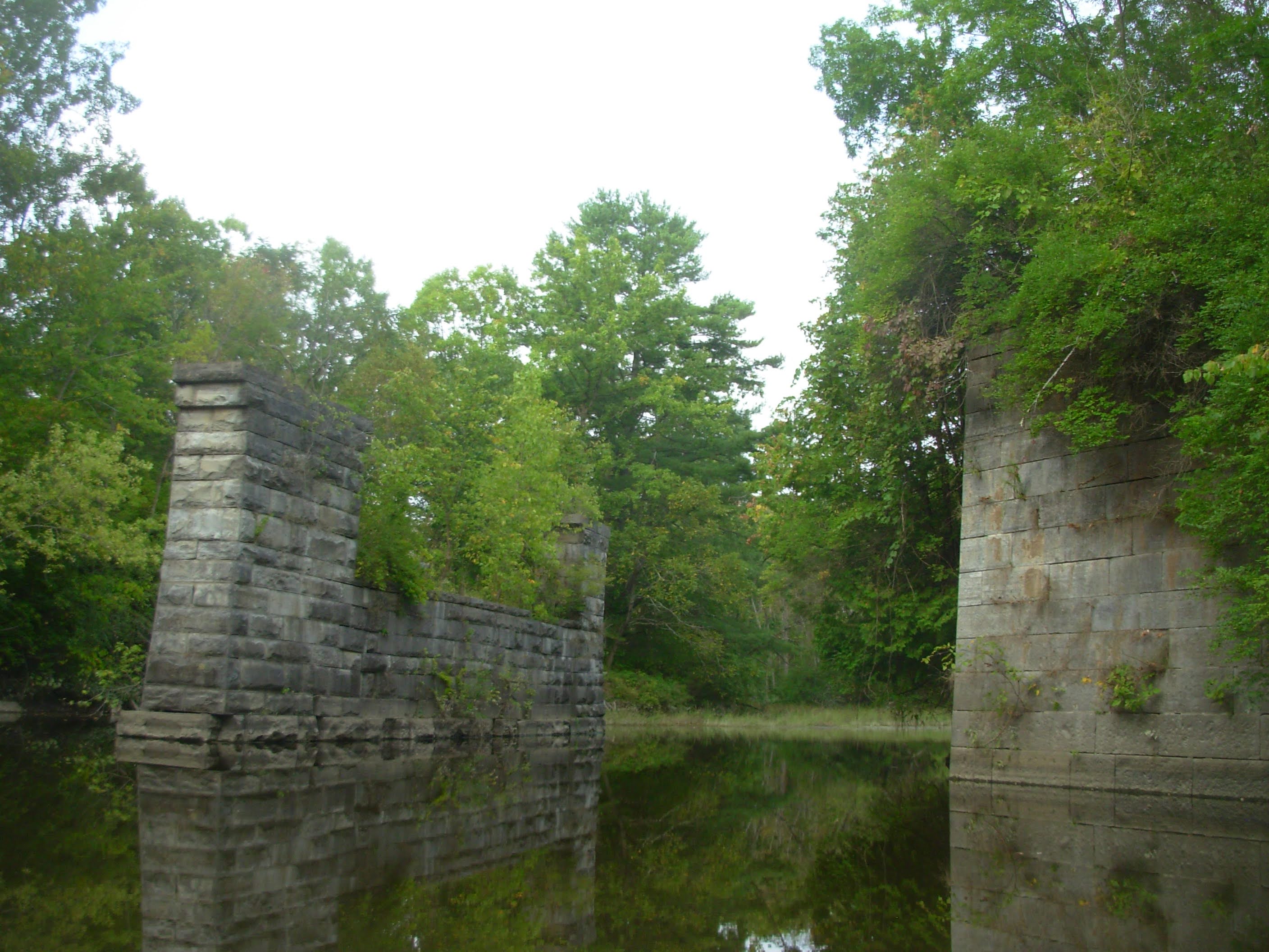
     If you stand on the new bridge that parallels the old Fenimore bridge and look upstream you'll see several piers in the river. These were built in 1836 to carry a railroad across on its planned route from Saratoga to Whitehall. Unfortunately, money ran out after the piers were built and the tracks and trestle were never finished. 


Never used RR piers with trash plant behind them.

 
     Another early bridge, this one over the South Bay of Lake Champlain, has been put to use as a fishing pier.


     Over on the other side of the county, in the Town of Salem, are traces of several other abandoned bridges.


Fitch's Point bridge over Black Creek


     At one time there was a connection between Cemetery Road and Rt. 22 running just south of Evergreen Cemetery. This abutment is all that is left of a bridge that carried the road over White Creek.


     You'll have to go to Rhule Road in Malta, N.Y. to see this parabolic arch truss bridge built in 1888. It used to span Black Creek upstream from Fitch's Point bridge at the intersection of Cemetery and Black Creek Road but was moved from Washington to Saratoga County when a new bridge was built.


     Also near Salem are several railroad bridges of interest. The abandoned D&H line from Salem to Castleton has been made into a popular rail trail on the Vermont side of the border while in New York it is posted and brush clogged. Sadly,  this is a lost economic and recreational opportunity that could be bringing dollars to local Washington County businesses much as it is now doing in Vermont.


Maintained rail trail bridge in Vermont


Derelict bridge in New York


     Stone arch bridges are always fun to find and when I heard there was one over Beaver Brook north of Salem I had to have a look. Maybe that was a mistake. It is there (sort of) near the intersection of Scotts Lake Road and Rt. 22 but it is not easy to view or photograph as these then and now images illustrate.

Then


Now

 
      I found another 'Then' photo of an impressive arch structure from Hartford. There's no 'Now' photo because the span is long gone.


     One arch that's still doing daily duty carries Rt. 197 over the Moses Kill in Argyle. Long may she span.


     The next one gets my vote for the most beautiful in all of Washington County. It vaults over Pike Brook in the Town of Dresden. To see this exquisite craftsmanship you have to walk down a bank where miscreants dump their broken TV's and various other modern garbage. Sad.


     Thank God no one has built a bridge across Lake George, although I'm sure it has been contemplated. But there have been some charming little footbridges and we'll finish with a look at two that used to exist on the east (Washington County) side of the lake. In Huletts Landing during the late 1800's several different bridges gave access to the Lakeside Inn on its rocky point.


     At Pearl Point near Shelving Rock there was another span that Elsa Kny Steinback tells of in Sweet Peas and a White Bridge. But 'Tells of' doesn't do this lovely memoir justice. Turns out that this 'White Bridge' plays a role in Elsa's own personal origin story. I've sat on shore reading her lyrical anecdotes and then paddled out into the Narrows, rounding Pearl Point on the way. While Lake George waves rocked my little boat, waves of nostalgia for Steinback's simpler times washed over me. Bridges to the past, indeed. 

Steinback's White Bridge in right background

   
There here, all but forgotten...

     Paddling Washington County's streams and rivers is what got me interested in old crossings. You see a stone pier or abutment and wonder about it. Should your curiosity be sparked by something you see I would recommend contacting the local town historian. They are great sources of information.
     I also like the website https://bridgehunter.com/ny/washington/
Happy bridge hunting.

Seen on the Moses Kill


Friday, August 12, 2022

Back to the Bridges

     Time to remember a few more bridges out of Washington County's past (as well as several with a future). Last post we looked at rail spans over the Hudson and Battenkill Rivers. Let's stick around Hudson Crossing for a bit and then move up the canal to revisit some of its 'ghost bridges'.


     This illustration by Tim Forbes shows the bridge of boats that General Burgoyne used to get his army from the east side of the river to the west in August 1777. It's one of the structures (albeit temporary) that gives Hudson Crossing its name. Given the outcome of the Battle of Saratoga a short time later, the British may have wished they never crossed over. An aside: it must have been fun to get those oxen over  wobbly planks set on top of rocking bateaux.

Aerial view of the Dix Bridge from Hudson Crossing's website


     The Dix Bridge and I go way back. I remember driving across it many times in the past. After it was closed to traffic I'ld hop the barricades and scoot over on running loops thru Clarks Mills and up towards Bald Mountain or along Windy Hill Road. Since 2013 you can actually do this legally after the bridge was refurbished for pedestrians and cyclists. It was originally built in 1895 as a 'free bridge' with no toll. I'm all for freedom and all for the Dix Bridge, which can be seen and strolled over from Hudson Crossing Park. 


     The Co. 113 bridge over the Battenkill between the Towns of Greenwich and Easton was replaced recently. The photos above are before and after shots. They did a nice job and now when I explore the river bed at low water I don't have to worry about the bridge falling on my head. You can approach it by canoe up the Battenkill or from along the bank where the H&V plant grants access. The mill doesn't seem to use the heavily wooded point of land at the confluence of the Hudson and the 'Kill. Maybe someday there could be trails here connecting to Hudson Crossing via the Dix Bridge.

     Both the older Champlain Canal and the newer Barge Canal had bridges that have come and gone with time. Let's look at what remains of a few:


     Not all bridges went over the canal. These 'then and now' images  are of an aqueduct that carried the canal above the Moses Kill. Best seen (along with the trolley bridge in the previous post) from a canoe.


     A towpath arch in Fort Edward alongside Rt. 4. That's Bond Creek just before it empties into the Hudson. Looks like beavers have contributed some engineering. 


     At Lock 9 of the Barge Canal in Smith's Basin you'll see these abutments of a former rail bridge over Wood Creek. The tracks went to a lime quarry/kiln just to the east. The only traffic here now are pleasure boats on the canal and bicycles on the Empire State Trail.


     Going, going, gone. Two photos from the web and one I took  document the fate of Dewey's Bridge in the Town of Fort Ann. It was built in 1911 and demolished in 2013. It crossed near where Winchell Creek flows into the canal (formerly Wood Creek). Why wasn't it left for pedestrians, cyclists and equestrians? A nearby sign tells the areas history.
 
Winchell Creek


     One of the most unique of the canal bridges was located in Whitehall. Known as the Clinton Street Bridge it was converted to a performance space called the Bridge Theatre. Originally built in 1911, it was condemned in 2009 and removed in 2015.

Web image


     You could do a book on bridges in and around Whitehall. With the Wood Creek/Champlain Canal, the Mettawee and Poultney Rivers plus railroads and highway crossings there have been a lot of bridges down thru the years. Old photos show a foot bridge over the canal that was wiped out by a barge and a covered bridge from long ago over Wood Creek. Gone and all but forgotten.
     I've got a few more interesting bridge sites to share so we'll have to do a third post soon.