The awe comes in the form of two waterfalls that I call 'The Bookends'. The name refers to the way they seem to bookend the river. One is far up in the headwaters and the other is just before the 'Kills confluence with the Hudson. You can visit both in a day making for a great spring outing. Prepare to be awed.
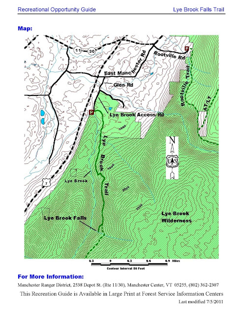
Start with a hike into the Green Mountains above Manchester, Vermont. From an access lane off Glen Road a trail leads up towards the Lye Brook Wilderness Area. You will be walking on woods roads and an old logging railroad bed. After a mile and a half be on the lookout for a side trail to the right. There may be a small sign pointing the way. This path leads to the base of Lye Brook Falls. Lye Brook is one of dozens of small feeders that flow off the slopes surrounding Manchester.
This is no thundering cataract. Instead, the appeal lies in its height and delicate architecture as the brook cascades down a stair-step series of ledges. Note that I haven't included a photograph. There's a reason. I wouldn't want to deny anyone the anticipation during the hike and the moment of bliss when the falls are suddenly revealed. Trust me and treat yourself to the 'live' experience.
Reach the second of 'The Bookends' by a scenic drive along the Battenkill from Vermont into New York. The river and the road first head south down the Valley of Vermont. This is a carbonate (limestone, dolostone, marble) floored physiographic feature bounded by the Greens to the east and the Taconics to the west. Both ranges were created during the Taconic Orogeny some 450 million years ago, but they are composed of different rock types and each has its own unique origin and history.
The river and the mountains at West Arlington
In an odd little maneuver, the river takes a sharp turn at Arlington and cuts clean thru the Taconics, creating a picturesque gap. It breaks out of the high mountains just beyond the state line and then winds thru low hills before skirting the Village of Greenwich and dropping over a limestone ledge at Middle Falls.
You can view these falls by turning right at the end of the Rt. 29/40 bridge. Look for an access path to their base off the short road leading down to the golf course. This spot has both natural as well as archeological interest arising from relics of past industry. While you might be tempted to think this waterfall is the Battenkill's last hooray, you would be wrong.
Below Middle Falls
Dionondahowa Falls lies just a short ways downstream from Middle Falls but you'll need to get back in your car for a short drive on Rt. 29 to Windy Hill Road, just past the Ice Cream Man. About a half mile down Windy Hill look for a small pull-off on the right. There is a sign and an obvious trail leading to several overlooks. Don't miss the view directly across the Devil's Cauldron facing the falls. Do keep a tight hold on pets and small children. And marvel at the volume and power the river has gained in its journey from Lye Brook to here.
Also marvel at the fact that these quiet woods once attracted people by the hundreds, brought here by an electric trolley line from cities to the south. The grounds surrounding the falls and gorge hosted a dancing pavilion, restaurant, bicycle track and baseball field. Today the only traces left of Ondawa Park are bits of the old trolley bed.
Some may remember the 2015 Battenkill Inspired exhibit at Crandall Library in Glens Falls. It included mementoes of Ondawa Park. Since then the library's Folklife Center has produced a series of short videos also called Battenkill Inspired. They feature scenic views of the river, interviews with artists and craftsmen as well as historical sketches, including one on the Hudson Valley Railway that brought people to Dionondahowa Falls. Access the videos here.
Image from Folklife video series
River Related...
Some Battenkill Conservancy notes:
* This year's Battenkill Runs Through It Festival will be on Saturday, May 25 from noon to 5pm at the Greenwich Town Beach.
* The conservancy recently had a work day at the Rexleigh Marble Mill and continues clean up at the site.
Conservancy photo
* Their Corridor Connections Project highlights river access points.
* Also of interest...
Looks like the Co. 113 bridge over the Battenkill at Clarks Mills (by the H-V plant) is being replaced. It's definitely in tough shape but I'm going to miss its graceful arches. I try to walk under it every summer when the river is low and most of the water is channeled thru the mill. Shale river bed below, concrete bridge arcing above.
Recently
A few summers ago


thanks for highlighting the best of the Battenkill watershed and some of the work we are doing to help promote its beauty while preserving and protecting its clean water and open space!
ReplyDeleteDon, while walking the Dahowa trail off of Windy Hill Rd i ventured beyond the trail boundaries in the downstream direction.
ReplyDeleteKnowing the Pulp Mill Road by H&V has 2 sets of rail piers i'd begun to deduce, due to the narrowness of the pier tops, the rail must have been a passenger rail to be that narrow, and recently reading several of David Nestle's books i found it was passenger, and was the electric trolley line built in 1900.
So searching for artifacts of that line by "the Hellhole", one of its local names, sure enough i found railbed "berms" pointing perpendicular to the Battenkill Gorge on the Windy Hill side.
The trolley line was powered by the hydro now below Boralex's hydro.
Hudson Valley Railway purchased the trolley line.
Ondawa Park was the crossing point over the Gorge, was quite popular in its day.